National Geographic’s "Tsunami: Race Against Time"
What you’ll learn:
- Insight into National Geographic’s Tsunami: Race Against Time docuseries.
- How the visual effects and simulations were designed.
- How the aftermath ushered in new advanced warning technologies.
On a sunny December morning in 2004, a magnitude 9.2 earthquake struck 100 miles off the coast of Sumatra in Indonesia. The energy released in that quake spawned a massive tsunami that reached 100 feet high, killing an estimated 227,898 people in 14 countries and devastating communities around the coasts of the Indian Ocean. Scientists have described the event as one of the deadliest natural disasters in recorded history. It caused the planet to vibrate as much as 10 mm and triggered earthquakes as far away as Alaska.
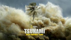
Now, 20 years later, a new documentary series is focusing on the events that took place that fateful day and the survivors who lived through it. National Geographic’s Tsunami: Race Against Time is a four-part series from award-winning producers Tanya Winston and Danny Horan and directed by Emmy Award-winner Daniel Bogado, known for his work on National Geographic's 9/11: One Day In America.
The new series highlights the events of December 26, 2004, from every angle, using a wealth of archival footage and advanced technologies that play out more like a dramatic thriller than a documentary series.
According to National Geographic, the new docuseries was three years in the making, with producers garnering around 300 hours of archival footage, including many never-before-seen moments from around the world. Interviews were conducted with over 100 individuals, with some speaking for the first time about their experience.
They worked in careful collaboration with scientists, local experts, and survivors to establish timings for the arrival and spread of successive tsunami waves on that day across multiple affected coastlines. They also tapped VFX Director Paul Silcox of Lux Aeterna and his talented team of visual artists to create the high-resolution simulations and imagery seen throughout each episode.
Creating the Tsunami Simulations
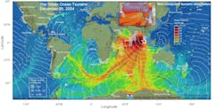
The process of producing those incredible simulations was incredible, to say the least. To produce that accurate imagery, Silcox tapped the National Oceanic and Atmospheric Administration (NOAA) and its Center for Tsunami Research for datasets that were garnered on December 26, 2004 (Fig. 1). The data was collected from Deep-ocean Assessment and Reporting of Tsunami (DART) buoys, radar satellites, the U.S. NOAA National Weather Service Tsunami Warning Centers, UNESCO/IOC-NOAA International Tsunami Information Center, the U.S. Geological Survey National Earthquake Information Center, International Post-Tsunami Field Surveys, and news organizations.
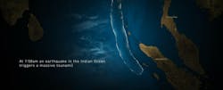
In total, over 37 billion data points were used to create those visuals (Fig. 2), which were processed using the Houdini 3D animation platform to create those incredible simulations. “They [NOAA] had five hours' worth of data from the Indian Ocean to India to Africa of the sea height. And that came to us in a CDF format,” explained Silcox on how they acquired the data. “232 gigabytes of net CDF data. That data had to be read into our software in order for us to visualize and process the data, which we did using Python. So, we actually processed the data in Houdini.”
Silcox and his team did an incredible job recreating how the earthquake and resulting tsunami appeared and moved over the entire Indian Ocean and how those giant waves impacted coastlines. The simulations' dynamic fluidity was ominous, more so when the viewer considers the sheer magnitude of what was about to happen and the resulting aftermath.
New Technologies for New Warning Systems
While the narrative presents a stark foreboding and the horrific aftermath of the various countries impacted, the natural disaster did bring about much-needed warning systems that weren't in place during that time.
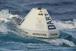
In the years since, the NOAA and other oceanic agencies around the globe have adopted new technologies that can provide advanced warning of ocean-borne earthquakes and tsunamis. These include Deep-ocean Assessment and Reporting of Tsunami (DART) buoys (Fig. 3) that can measure a tsunami wave as small as 1 centimeter and provide that data in real-time to forecast how high the wave will be and when they will hit coastlines.
Scientists have also developed advanced forecasting system models that incorporate local topography and historical tsunami data to accurately predict exactly how a wave might behave when it hits the shore. Time is the x-factor in advanced tsunami warnings; the more there is, the more people can evacuate.
National Geographic’s four-part docuseries Tsunami: Race Against Time is set to premiere on November 24, 2024, and begins streaming the following day on Hulu and Disney+.
Check out the trailer:
About the Author
Cabe Atwell
Technology Editor, Electronic Design
Cabe is a Technology Editor for Electronic Design.
Engineer, Machinist, Maker, Writer. A graduate Electrical Engineer actively plying his expertise in the industry and at his company, Gunhead. When not designing/building, he creates a steady torrent of projects and content in the media world. Many of his projects and articles are online at element14 & SolidSmack, industry-focused work at EETimes & EDN, and offbeat articles at Make Magazine. Currently, you can find him hosting webinars and contributing to Electronic Design and Machine Design.
Cabe is an electrical engineer, design consultant and author with 25 years’ experience. His most recent book is “Essential 555 IC: Design, Configure, and Create Clever Circuits”
Cabe writes the Engineering on Friday blog on Electronic Design.


