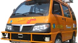
VisLab's autonomous robots are headed to Shanghi, China
VisLab's solar cell roof provides power to the navigation system
VisLab's navigation system uses a network of standard components
Keeping system in the open provides easy maintenance
A passenger's view of the robot and the cutoff and control system
VisLab's crew will travel with the robots to China
VisLab Intercontinental Autonomous Challenge is a big game of follow the leader but with autonomous robots. Details can be found at on Wikipedia and at VisLab's website. The pair of robots are autonomous vehicles designed to follow each other without any human intervention on a 13,000 km trip from Parma, Italy to Shanghai, China
The destination is the 2010 World Expo whose theme is “better cities, better life”. There is a good overview on Wikipedia 2010 World Expo entry. The challenge is to reach Shanghai with the two driverless vehicles. Passengers will be riding in the two driverless vehicles so they can intervene if an emergency arises. The project is partially funded by the European Research Council (ERC).
The vehicles and much of the other hardware and software was provided by a range of companies. Piaggo Porter Commercial Vehicles provided the five vehicles used in the system including the two autonomous vehicles used in the challenge. TopCon provided the CAN-based servo motor on the steering wheel, the GPS, and the UHF radio for vehicle-to-vehicle communication. Thales Computers provided the on-the-halt and on-the move satellite communication systems, bandwidth for live image streaming, and sat-phone coverage. IBM provided systems for for CO2 sensing and GPRS coverage for data communication. Enfinity provided the monocrystalline Enfinity 240M6 solar panel.
Hardware and Sensor Suite
The robots are electric vehicles. They all have a load of batteries that provide motive power. The solar panels provide power only to the automatic driving system. The solar support highlights green power but the main batteries are recharged at night.
A number of laser and radar systems are space around the vehicle. These provide obstacle recognition as well as tracking vehicles ahead and behind. In front on the roof is a pair of color cameras provide short range (80cm) object recognition. The laser scanner in center on the roof provides more accurate distance information.
There is a panoramic vision system about where the rear view mirror is located. It has 3 camaras and is designed to track the vehicle being followed. Also in front on the bumper are a pair of laser scanners on the left and right. They have a range of 30m with a 240 degrees scan area. The laser scanner on the center of the bumper is a 4 plane scanner with an 80m range and 100 degrees span.
On the back is a pair of rear color cameras, essentially a rear view mirror. On top of the vehicle is the localization system. It contains the GPS system, inertial sensor suite, and the UHF transceiver for remote communication.
There are two connections to the outside world. One plug provides access to the computer network. It includes an Ethernet connection. The engine power plug is for recharging the batteries.
The ruggedized computers are mounted inside the passenger cab. Multiple Mini-ITX systems are networked together using Ethernet.
The Challenge
The lead car will be following its own plan although human operators may intervene at times because there are not maps to all the areas being navigated. If intervention is needed, other than emergencies, it will be a matter of recommending the direction to go. The second car will be following the first unless it loses site of the lead car. The cars will have passengers but they will be observing, not helping. The observers can take control in an emergency.
The trip will not be in a specialized or limited environment as the DARPA challenges have been. The caravan approach provides a safety factor while placing the robots in a real environment. The robots are definitely pushing the envelope.
The robots will need to addres a wide range of environments with variations in road conditions, weather, infrastructures, temperature, traffic, and even possibly unlawful behavior of other road participants. The navigation system has a map of the trip and will track the vehicles location using the navitation system's GPS and inertial guidance system. The trip is over 13,000 km. Human intervention will be required to attach charging cables at night but little else.
The vehicles are all electric. They will be running through extreme environments so this is not only a robot challenge but an electric car engineering challenge as well.
The vehicles may look ungainly because sensors are mostly outboard but this has advantages. First, it makes repair or adjustment easier. Second it highlights the hardware used. Power generators will be available in additional vehicles to provide recharge facilities when external power is not available at night. Some of the trip will be off the beaten path. The range of the vehicles is 100 km and the maximum speed is 60 km/h. Average speed will be lower.

