A tragic World War II training exercise may now find some closure. A mission off the coast of South Devon, England—completed by Hydroid Inc.—has observed two U.S. Landing Ship Tanks (LSTs) that were sunk by German torpedo boats during the D-Day rehearsal “Exercise Tiger” on April 28, 1944. The exercise was one of several rehearsal trainings for the invasion of Normandy’s Utah Beach, in which nearly 1,000 U.S. servicemen died. Autonomous underwater vehicle (AUV) technology has been used to collect data from the wreckage site, providing the first high-definition sonar images of the wreckage from this tragedy.
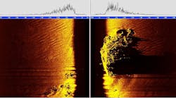
Hydroid Inc., manufacturer of AUVs, employed its REMUS 100 for the mission, with additional data supplied by the Royal Navy’s Maritime Autonomous System Trials Team (MASTT) (see Figure 1). This mission commemorates the 70th anniversary of Exercise Tiger. REMUS 100 was created for intricate oceanographic surveys over large areas and outfitted with multiple sonar instruments enabling it to take high-resolution imagery of objects on the sea floor. It was able to take a high-quality side scan and wide- swath interferometric bathymetric multi-beam sonar images of the two LSTs located 50 m below the surface (see Figure 2).
The search was split up, with Hydroid operating in the English Channel 30 miles out to sea and MASTT focusing just off the Slapton Sands—the location of Exercise Tiger’s beach landing. Hydroid and the Royal Navy will be donating images from its mission to the UK National Archive and local memorials. The project will help bring new information regarding the tragedy to light and offer families of those lost some measure of closure.


