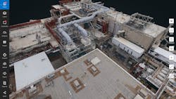
Intel has gotten into the drone world in a big way, literally. It has picked up or partnered with a wide range of companies in this space to deliver drone hardware and software, including its soon-to-be-released, cloud-based, enterprise-oriented Intel Insight Platform, in addition to its Shooting Star drone swarms. The Insight Platform digital asset management system can combine and manage data from multiple drones and drone flights (Fig. 1). The system is scalable allowing it to handle data about multiple installations such as buildings. Data can be combined because it includes time-stamped and geo-referenced images. Typically the data are images, but other sensor information can be utilized as well depending upon the drone’s payload.
1. Intel’s Insight Platform combines and manages drone data to help create 3D models like this.
“We are pleased to announce a suite of new Intel drone technology at Xponential,” said Anil Nanduri, vice president and general manager of Intel’s drone team. “Now companies can come to one supplier, and a name they know and trust, for their hardware and software needs—providing them with more tools to capture critical information about their assets, process and analyze it, and make insightful decisions for their business.”
Some of Intel’s partners for the Insight Platform include Bentley and Pix4D, two well-known names in the drone software industry. Users of the Insight Platform have access to their tools that can be used to generate a 3D model of a building from captured data to analyzing the images to identify anomalies. These type of inspection chores can be used for applications like roof and power line inspections.
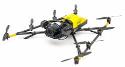
The Falcon 8+ and Sirius Pro drone are two platforms that Intel provides. The Falcon 8+ (Fig. 2) now has UL 3030 certification. This includes electrical safety protection of batteries, chargers, and end products against electric shock and fire. The certification evaluates the enclosure strength, functional safety requirements, motor safety, protection against injury, performance, and autonomous features of the system. This is the first drone to receive the certification.
2. Intel’s Falcon 8+ is the most common drone used with the Insight Platform.
Intel announced three new payloads for the Falcon 8+ designed for inspection, surveying, and mapping applications. The Intel High Resolution Imaging Payload captures 42-megapixel images. It is based on Sony’s full-frame RX1R II camera. It can capture high-resolution images needed for detailed inspection.
The Intel Imaging Payload and Intel Dual Imaging Payload each support obstacle-avoidance capabilities of Intel’s RealSense technology to help enable safer missions. This system features a 20-megapixel Sony UMC-R10C camera. The Intel Dual Imaging Payload uses two cameras mounted on a single gimbal for simultaneous RGB image capture and thermal imaging.
The Sirius Pro fixed-wing UAV can cover larger areas than the Falcon 8+ (Fig. 3). It is ideal for covering items over long distances, such as agricultural areas using payloads like the MicaSense RedEdge that combines five discrete spectral band sensors into a single package. It can also use payloads like the Sony RX1R II camera.
3. Intel’s Sirius Pro drone is a fixed wing UAV designed for endurance.
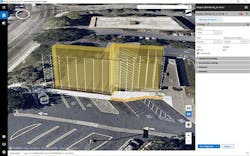
As noted, roof inspection is one of the applications suitable for the Intel Insight Platform (Fig. 4). A drone can easily record the images while flying the same pattern over many months. Each flight can generate a large amount of data that is then delivered to the platform. The web-based interface allows users to access the captured and analyzed data, but it does not all have to be at the original high-resolution recording. Instead, the system can recognize the user’s requirements and access and present the information in a useful format limiting the amount of data presented to the user. The user can pan and zoom where subsequent presentations may deliver higher-resolution images.
4. Roof inspection is one application of Intel’s Insight Platform.
Intel is working with partners and enterprise customers to support features like the creation of digital twin models based on captured data. Likewise, this data can be used with a digital twin model to provide time-oriented history, as well as the current state of affairs (albeit from the last drone flight).
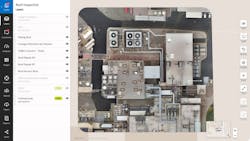
On offshoot of the platform’s support is Intel’s Mission Control (Fig. 5). This can be used to create flight plans that drones will use to capture data. The sophistication of the planning is significant because the recording of the data often needs specific recording waypoints to provide consistent imaging. For example, nap-of-the-earth (NOE) flying allows the image capture hardware to be oriented consistently.
5. Intel’s Mission Control helps plan sorties for capturing images and data.
The Insight platform is in beta, and Intel is only working with large enterprises at this point. If your requirements are not quite as massive, and one or a few drones may handle your requirements, then other companies like Parrot may be an option. Parrot also has a number of solutions where it hard partnered with companies like Pix4D to create 3D models of homes and buildings or to track agriculture activity. The packages include the drone with matching software support in the cloud.
Commercial drone technology is getting more sophisticated and easier to use. Intel’s Insight Platform takes this to another level where there is a large amount of data and drones will be used on a regular basis over the months or years to capture data. The Insight system is a work in progress, but it will have the capability of integrating with other systems so people can be notified with machine learning systems detect changes—such as with the roof inspection system—that will require human intervention.


